![[A horse-drawn Imperial Oil Company delivery wagon]](/uploads/r/null/2/2/2224e4a5d97c90e0a778ace278dca8e24902c2d94f4547b4e7807efc094288fc/d0a09002-ff77-467f-bbee-c803d196e63b-A37624_142.jpg)
[A horse-drawn Imperial Oil Company delivery wagon]
- AM54-S4-: Trans P169
- Item
- 1912
Part of Major Matthews collection
Photograph shows Billy Dion driving
41 results directly related Exclude narrower terms
[A horse-drawn Imperial Oil Company delivery wagon]
Part of Major Matthews collection
Photograph shows Billy Dion driving
![[Barricade on the Georgia viaduct]](/uploads/r/null/2/a/2abaedfc354b716e2e263b1fe76ebc6b906f65c5773720d23e220d49b3519af9/62841705-58ab-41bd-8bce-6e0208436f93-A24553_142.jpg)
[Barricade on the Georgia viaduct]
Part of Major Matthews collection
Photograph shows the B.C. Electric gasometer.
![[Barricade on the Georgia viaduct]](/uploads/r/null/8/0/805ce3a3123a1fd07185489303b36756289a2f540189ac179bf6ef93b2f15cb9/24f52fd7-9b1b-48d6-86ca-9d03a3c3ea63-A24546_142.jpg)
[Barricade on the Georgia viaduct]
Part of Major Matthews collection
Photograph shows the B.C. Electric gasometer.
![[Barricade on the Georgia viaduct]](/uploads/r/null/4/f/4f8863610ed274491934797b4e67dee5e8af776882cd41bb2b0aadeba058e978/0be9c8de-88c9-4c3e-9f3c-3dbd99b6aa49-A24552_142.jpg)
[Barricade on the Georgia viaduct]
Part of Major Matthews collection
Photograph shows the B.C. Electric gasometer.
BC Electric : Please do not fold transfer
![B.C.E.R. [British Columbia Electric Railway] Company coke truck](/uploads/r/null/c/7/c7036b453312f9e6bcbf085527f5a1abcaac454f88b8746d71b0c9ae5d5ec9c0/9dc43a22-5a52-4f87-843a-0335e4aabf55-A19075_142.jpg)
B.C.E.R. [British Columbia Electric Railway] Company coke truck
Part of Stuart Thomson fonds

Part of Stuart Thomson fonds
Photograph shows the center span and a marine Home Gas station
![Burrard Bridge [view looking south from Pacific Street near Thurlow Street]](/uploads/r/null/5/8/58f8c1c77a07ac57ac06f8064fd456f02e193810eacc141ad134a3cd04ecd3ba/f1b103f9-dc43-47ee-aff4-24a709af4675-A18310_142.jpg)
Burrard Bridge [view looking south from Pacific Street near Thurlow Street]
Part of Stuart Thomson fonds
![Can. National Oil Tanks [north foot of Main Street]](/uploads/r/null/f/6/f6a5288b42f1d10452de777417cdb32d61eaedfb211a167f523ad3b2194f8096/156f00fd-ef41-4826-9f1b-428c2ed7054d-A21905_142.jpg)
Can. National Oil Tanks [north foot of Main Street]
Part of Walter E. Frost fonds
![Coal pile [at] Pacific Mills](/uploads/r/null/3/b/3b4d853cb4b9f9fb68be0126acb2c15c3aa4e2f954a53a1a9b8797eba14bcec7/28501efd-f931-48e3-95d8-acc7653ea8a1-A14752_142.jpg)
![[C.P.R. fuel tanks near the foot of Cardero Street]](/uploads/r/null/2/5/25d045a5c71ee6055631537cf9b4d8055cf8c5aaa7538e35395fe8f871337d24/fe7903f8-69a6-4ad7-aafe-6a4095dd632d-A63068_142.jpg)
[C.P.R. fuel tanks near the foot of Cardero Street]
Part of Major Matthews collection
Photograph shows the Vancouver Rowing Club and Deadman's Island in the background
![Erection of Oil tank [Construction of the CPR fuel oil tanks]](/uploads/r/null/9/d/9d356f200685ac09713d8fd9e9e3ae9c108a5961a9484e5584f6b483112b936b/c34deb5d-0727-44bd-a226-e7b234f07cf3-A49470_142.jpg)
Erection of Oil tank [Construction of the CPR fuel oil tanks]
Part of H.A. Price collection
Photograph shows the construction of the CPR fuel oil tanks on the Vancouver waterfront. Image includes men working on the CPR tracks.
![[Fire erupts in stacks of peat on Lulu Island]](/uploads/r/null/c/b/cb9abdf404844296f29410d9ef42aba2bbfd3ebc5fa485a4307733c958c22a65/3911cf8c-6d8d-4fcd-8c1e-bc0d07823343-A33207_142.jpg)
[Fire erupts in stacks of peat on Lulu Island]
Part of Major Matthews collection
![[Imperial Oil Company fuel storage tanks at 234 Smith (Glengyle) Street]](/uploads/r/null/1/c/1c8551678d6de34312a03a2a63ed79020e292b89065a6c6aa6901490981c1702/198d3529-9b39-41fc-9129-839a62642839-A37623_142.jpg)
[Imperial Oil Company fuel storage tanks at 234 Smith (Glengyle) Street]
Part of Major Matthews collection
Photograph shows John E. Hayden in front of the office and Syd Alexander at the pump
![[Interior of] B.C. Peat plant](/uploads/r/null/7/2/7298c895fbd5fa6e203311b5f4feece21dcf18347d4c346cf0f73b61990e081d/49760aaf-02b5-491e-a7be-6bec8b30c58c-A06342_142.jpg)
![[Interior of] B.C. Peat plant](/uploads/r/null/5/2/525d2f82b2bbeba6968e31a856e31e89a0e9e535de1e7e2b0b21eb6d52a5ca15/2814aac5-3d50-4d08-b552-491890f9319a-A15166_142.jpg)
![[Man checking peat at] B.C. Peat plant](/uploads/r/null/0/4/0434223888ca1077019fb74fdd8904cfc659b94eed7b1f66b038d5fd28be88a9/2bfd0c43-1fe6-4028-b9d1-45c845e2d350-A15167_142.jpg)
[Man checking peat at] B.C. Peat plant
![[Man tending peat moss processing machine at] B.C. Peat plant](/uploads/r/null/6/6/6633e44dbda27aaff05389a391d38638776dfd925e70f693b6d799b35c9972c3/f1b76ccf-d178-4ab3-8655-9bd2c2897a5b-A15165_142.jpg)
[Man tending peat moss processing machine at] B.C. Peat plant
![[Man testing bundle of peat moss at] B.C. Peat plant](/uploads/r/null/5/8/588165e669fe5dd6f765c92ec46ae20c8d7dd7e101a1743ccb4aadc2c1be22af/3c7a1dd2-01b6-4ac9-a950-d8d22bb1791c-A15164_142.jpg)
[Man testing bundle of peat moss at] B.C. Peat plant
![[Men at work at] B.C. Peat plant](/uploads/r/null/e/d/ed204f51642e736bf3ea1c33003fdcecd364acd1c94fde6cb639b2dfa093ab11/89350e74-e885-4faf-bd99-40fdd35b3fa9-A15168_142.jpg)
[Men at work at] B.C. Peat plant
Petroleum fuels in Canada : deliveries for consumption, calendar years 1927-1940

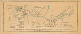
Plan showing locations of oil and gas seepages and oil wells in Fraser Valley, British Columbia
Part of City of Vancouver Archives technical and cartographic drawing collection
Item is a map which shows rivers and streams, oil and gas seepages, oil wells drilled, towns and villages and railway lines from Pitt Lake in the north to the United States border in the south and from Chilliwack in the east to the Strait of Georgia in the west.
Haggen, E.A.
Rates for gas : Lower Mainland area
Rates for natural gas : Greater Vancouver area
Rules and regulations for the supplying of gas in Vancouver
Service station in British Columbia
![Shell Oil truck [making delivery to a gas station]](/uploads/r/null/a/c/ac60dcfa4afd29ec64eb16fae0f885c2aacb9237eebcbbac96b8b050046d6964/54b539d2-7e1f-45ac-b7ff-9a301e2248b3-A19120_142.jpg)
Shell Oil truck [making delivery to a gas station]
Part of Stuart Thomson fonds
![Shetland ponies and wagon [filled with McLeod River Hard Coal from Alberta]](/uploads/r/null/5/5/5500926b6aecc8359aa9d36119571ff4acc04dc139eea70f8a328daa742d8eda/c1f5e5ad-d6db-4d89-a334-a5c7b0e9e145-A19092_142.jpg)
Shetland ponies and wagon [filled with McLeod River Hard Coal from Alberta]
Part of Stuart Thomson fonds
Photograph shows a sign advertising CKWX radio and a microphone and the second Hotel Vancouver in the background

Part of Stuart Thomson fonds
Photograph shows a sign advertising CKWX radio and a microphone
![[Smoke billows over stacks of peat during fire on Lulu Island]](/uploads/r/null/c/3/c37a43fb79845652bbd2e7c3ee7dd9808aa4249af81e63197f04e49bed0645e3/6b9c58d5-bc27-42fb-9612-1544a3a59a05-A33206_142.jpg)
[Smoke billows over stacks of peat during fire on Lulu Island]
Part of Major Matthews collection
The financial news : Western oil development progress number
![[Two women packing peat moss at] B.C. Peat plant](/uploads/r/null/d/a/da173a6109e5814827967a413dc904611c0c1c16720759b41c4817f4cdf12ea0/d3425c68-0a64-4fad-a079-eb8da87b434f-A15163_142.jpg)
[Two women packing peat moss at] B.C. Peat plant
Part of John William Freeston fonds
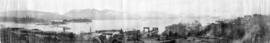
Panoramic view showing fuel oil tanks at the foot of Bute Street, Coal Harbour, the Vancouver Rowing Club, Deadmans Island, Brockton Point, the C.P.R. freight car ferry dock, the Immigration building, C.P.R. Pier A and Pender Street west of Burrard Street

![[View of lumber and stove wood in yard of Coast Lumber and Fuel Co. Ltd.]](/uploads/r/null/f/d/fdc99b7d8470f1159369cd9b16371019299e08d43c015397502d075afa09cfb4/6bbc92af-9058-45b9-b09a-9258157619d8-A63979_142.jpg)
[View of lumber and stove wood in yard of Coast Lumber and Fuel Co. Ltd.]
Part of Major Matthews collection
What's this thing called gas ... : [explanatory pamphlet about natural gas]