!["Lost Mine" - Lots Of Sparkle? - [camera rolls] 1-3](/uploads/r/null/1/2/1228427/87f57fea-95b8-42f9-888b-5b77a1ba730b-MI-315_142.jpg)
"Lost Mine" - Lots Of Sparkle? - [camera rolls] 1-3
- AM1553-8-S4-: MI-315
- Item
- Nov. 4, 1993
Part of Yaletown Productions Inc. fonds
Film contains raw footage for the film "Curse of the lost gold mine."
1100 results directly related Exclude narrower terms
"Lost Mine" - Lots Of Sparkle? - [camera rolls] 1-3
Part of Yaletown Productions Inc. fonds
Film contains raw footage for the film "Curse of the lost gold mine."

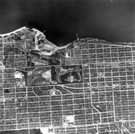
Aerial photo, vertical, False Creek, Fairview to Kits Point
Item is a photograph of False Creek, showing English Bay to W 16th Avenue, and from Maple Street to the Cambie Street Bridge. Includes the Burrard Street Bridge, the new Granville Bridge, the Cambie Bridge, and Granville Island.

Aerial photo, vertical, University of British Columbia and University Endowment Lands

Aerial photo, vertical, Little Mountain and Oakridge and surrounding area
Item is a photograph of Little Mountain and Oakridge, showing from W 30th Avenue to W 54th Avenue, and from Hudson Street to Main Street. Includes the Langara golf course and Queen Elizabeth Park.

Aerial photo, oblique, downtown Vancouver to North Shore Mountains
Item is a photograph of the Vancouver area looking northwest over downtown Vancouver including the Hotel Vancouver, Provincial Courts, the Marine Building, Stanley Park, Burrard Inlet, Lion's Gate Bridge, and Coal Harbour.

Aerial view of Little Mountain area
Item is an aerial photograph showing an oblique view of the Little Mountain area.
![[Aerial view of] British Pacific Properties [and North Vancouver]](/uploads/r/null/1/4/14644a75d43dd6a85d7a3c082e63134f4994ac268e97d1c0940f786b344bbd7e/46041e12-d683-4b08-81b0-797947030f8f-A23485_142.jpg)
[Aerial view of] British Pacific Properties [and North Vancouver]
Part of Major Matthews collection
Oblique view. Photograph shows Lions Gate (First Narrows) Bridge
![[Aerial view of Gibson's from 1000 feet]](/uploads/r/null/d/5/d58c7a9e607bc9f48df5886422ab0aba4830b659d95dc8901154f7dd62e737dd/5636f7ef-5742-455c-8626-5939b6fe11c5-A23483_142.jpg)
[Aerial view of Gibson's from 1000 feet]
Part of Major Matthews collection
![Vancouver looking east from [Howe Sound]](/uploads/r/null/6/6/66fa4a6e8bb1ab5d20d8f951fa93ad57dd828be645aff6d182d88a8b36c69281/69bee6e1-54a6-4c8f-a7db-043e03b4dfe6-A23503_142.jpg)
Vancouver looking east from [Howe Sound]
Part of Major Matthews collection
Oblique view. Photograph shows Point Grey, University of British Columbia and University Endowment Lands.
Typewritten letter from Hunting Survey Corporation Limited on verso of print.
![[Aerial view looking north over] Granville Island](/uploads/r/null/8/3/83f9be0a597100103c181fa4d68c68baa4a0802471126afafea3b7850103e12b/ea9e7fb6-7465-4fa6-8fa9-18923e3d9307-A49646_142.jpg)
[Aerial view looking north over] Granville Island
Oblique view showing the Granville Bridge and the new Granville Bridge under construction, the Kitsilano Trestle Bridge, of the Burrard Bridge and the industrial and undeveloped areas on the north and south sides of False Creek

Aerial photo, oblique, 41st Ave. and Oak St., Vancouver
Item is a photograph from Oak and 41st Ave, looking north, with a large partially cleared green area at the bottom of the frame, with downtown, Stanley Park, and the North Shore Mountains in the upper frame.
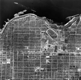
Aerial photo, vertical, Exhibition Park and surrounding area
Item is a photograph of Exhibition Park and the surrounding area, looking north. The area photographed runs from Vancouver Harbour to Charles Street, and from Lakewood Drive to Skeena Street.

Aerial photo, vertical, Marpole and junction of Fraser River, Bridgeport
Item is a photograph of Marpole and northern Richmond, looking north. The area photographed centres on the fork of the Fraser River at Sea Island, and runs from W 67th Avenue to Cambie Rd., and from the western most tip of Richmond Island to the west tip of Mitchell Island. Includes the Marpole Bridge and both Oak Street and Moray bridges under construction.

Aerial photo, vertical, Deadman's Island, Coal Harbour and surrounding area
Item is a photograph of Deadman's Island, including Coal Harbour, and the southwest part of Stanley Park. Compass north is the left side of the photo.

Aerial photo, oblique, CPR docks in foreground, looking south Granville Street at centre
Item is a photograph of the Vancouver waterfront, looking southwest down Burrard Street, showing the waterfront and downtown Vancouver, including Waterfront Station, Hotel Vancouver, Marine Building, Burrard Bridge, Granville Street Bridge, and the city beyond.
Aerial photo, vertical, Jericho Beach Park and Kitsilano
Item is a photograph of Jericho Beach Park and the surrounding area, looking north. The area photographed runs from English Bay and Jericho Beach to W 16th Avenue,and from Sasamat Street to Balaclava Street.

Aerial photo, vertical, Iona Island and Fraser River
Item is a photograph of Iona Island. The area photographed includes the northwest corner of Sea Island and the southwest corner of Southlands. Rafts of lumber are visible.
![[Aerial map of Greater Vancouver]](/uploads/r/null/5/6/0/560c4a977bf4bd23ded38e3e8d0c471a86a303d135869c5e459d1977eeed33a6/f660f804-da91-422b-9622-82ae60a89bbe-MAP358_142.jpg)
[Aerial map of Greater Vancouver]
Part of City of Vancouver Archives technical and cartographic drawing collection
Map is a poster of an aerial photograph showing Vancouver, North Vancouver, West Vancouver, Richmond, Burnaby, Delta, Coquitlam, Port Coquitlam, Port Moody, and Surrey. It also shows location of Sea Island Industrial Park and Lake-City Industrial Park which Webb & Knapp sponsor. "Lake-City Industrial Park and Sea Island Industrial Park, comprising approximately 900 acres of industrial estate property".

Part of Major Matthews collection
Oblique view showing the A.C. Taylor farm

Aerial view of Brockton Point in Stanley Park looking south
![[Aerial survey photograph with river]](/uploads/r/null/f/e/fe98d2abefe97f551eec30eb0326bbb273e1ee059396e9f6909ffc1984a9f7ea/6786642e-fcc8-4f00-bf6d-26d122fae5ec-A38258_142.jpg)
[Aerial survey photograph with river]
Part of City of Vancouver fonds
Aerial of Vancouver, B.C. [over False Creek]
Item is a photograph showing the Burrard Street Bridge, former train trestle and the West End neighbourhood as well as other parts of downtown.
Aerial shot from over Stanley Park
Item is a photograph showing Coal Harbour (left) and English Bay (right) and downtown buildings centre.
Summer 1982 - Aerial shot from the south side of False Creek before Expo
Item is a photograph showing housing complexes along the south shore of False Creek and on the north side construction has begun for the Expo 86 site and BC Place Stadium is under construction, past the Cambie Bridge on the right.
Item is a photograph showing downtown Vancouver from English Bay with Beach Avenue and Jervis Street and the former Tudor Manor apartment building visible.
![[Aerial view of the construction of the Deas (Massey) Tunnel]](/uploads/r/null/4/2/427b9c1a187745eb075c78ac228437392381ab4f50b1f4bf255c66efea55880d/5f92abf3-38c1-4c3a-9916-22338f6c99a5-A61247_142.jpg)
[Aerial view of the construction of the Deas (Massey) Tunnel]
Part of Major Matthews collection
Oblique view showing construction progress
![[Aerial view of the recently opened Deas (Massey) Tunnel]](/uploads/r/null/d/7/d7559c73b661cc7e8ed085c039d748d59692a531dd45579060162608c8118845/35561741-5971-4f8d-ad2e-bf938eef38b9-A61246_142.jpg)
[Aerial view of the recently opened Deas (Massey) Tunnel]
Part of Major Matthews collection
Oblique view
![[Aerial view of City of Vancouver, image of printed photograph]](/uploads/r/null/a/6/5/a6568a4fca40576b2d2b079a13541a80ace37c89086c2a64db6237dfdb087262/fb145724-094b-4d2e-9a60-24df3aef9c61-CVA1095-06997_142.jpg)
[Aerial view of City of Vancouver, image of printed photograph]
Part of City of Vancouver fonds
![[Aerial view of City of Vancouver, image of printed photograph]](/uploads/r/null/3/b/6/3b6df85f34e645db70d12e261cd1a8c0cea08edc95e2716ce32a92dc881a5878/efd40a47-faf5-435c-8b80-2f9099c88723-CVA1095-06996_142.jpg)
[Aerial view of City of Vancouver, image of printed photograph]
Part of City of Vancouver fonds
![[Aerial view of City of Vancouver, image of printed photograph]](/uploads/r/null/f/3/2/f3234fb45e4f46831886bd2cb6694f50a56ee898e4f2bd5b62dac4912067f52e/e5d60571-6952-41a6-8a5f-aba132b36f28-CVA1095-06995_142.jpg)
[Aerial view of City of Vancouver, image of printed photograph]
Part of City of Vancouver fonds
![[Aerial view of City of Vancouver, image of printed photograph]](/uploads/r/null/7/0/d/70d11e62ad0119a7483a61fe5f3229fcc4e1aacd651e6722db2466c5a80a8dcb/35b64a80-d60d-4551-89eb-87a5b81ac347-CVA1095-06994_142.jpg)
[Aerial view of City of Vancouver, image of printed photograph]
Part of City of Vancouver fonds
![[Aerial view of City of Vancouver, image of printed photograph]](/uploads/r/null/8/0/3/80337fd039988f10176eb1c593eb6cacff2aceac861957b1ea4b7be13e8b5ce7/1bdf7acc-f42b-4f15-bd32-4d7c837f7829-CVA1095-06993_142.jpg)
[Aerial view of City of Vancouver, image of printed photograph]
Part of City of Vancouver fonds

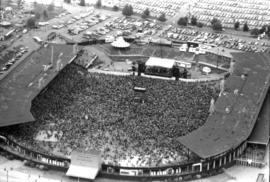
Aerial view of crowd at outdoor concert in Empire Stadium
Item is a photograph showing the Summer Sunday '78 concert with performances by Heart, Little River Band, Bob Welch and Nick Gilder.
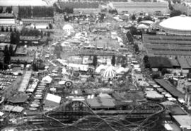
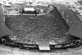
Aerial photographs of P.N.E. grounds and crowd at outdoor concert in Empire Stadium
Item is a photograph showing the Summer Sunday '78 concert with performances by Heart, Little River Band, Bob Welch and Nick Gilder.

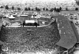
Aerial view of crowd at outdoor concert in Empire Stadium
Aerial view of crowd at outdoor concert in Empire Stadium

Aerial view of crowd at outdoor concert in Empire Stadium
Aerial view of crowd at outdoor concert in Empire Stadium

Aerial view of crowd at outdoor concert in Empire Stadium

Aerial view of crowd at outdoor concert in Empire Stadium

Aerial view of crowd at outdoor concert in Empire Stadium
Aerial view of crowd at outdoor concert in Empire Stadium

Aerial view of crowd at outdoor concert in Empire Stadium

Aerial view of crowd at outdoor concert in Empire Stadium

Aerial view of crowd at outdoor concert in Empire Stadium

Aerial view of crowd at outdoor concert in Empire Stadium

Aerial view of crowd at outdoor concert in Empire Stadium

Aerial view of crowd at outdoor concert in Empire Stadium